I like to take a backpacking trip in the late summer/early fall each year. It forces me to stay in shape and it allows me to explore different regions of the country fairly inexpensively. You save a lot of money when you sleep for free in the backcountry. Most importantly, these trips allow me to step away from the grind and recenter myself. In 2016, I thru-hiked the Foothills Trail on the North Carolina/South Carolina state line. In 2017, I thru-hiked the John Muir Trail in California. In 2018, I section-hiked the Uinta Highline Trail in Utah. In 2019, my goal is to thru-hike the Tahoe Rim Trail (TRT) on the Nevada/California state line.
This isn’t just another vacation for me. I experienced a compound fracture while backpacking through the Linville Gorge in November 2018. It’s actually worse than that. I broke both of the bones in my left calf and actually had to use a rolled-up bandana to pop my tibia back into my leg. You can read all of the gory details here: My leg and the Linville Gorge. I was on a walker and then crutches until March 2019 when I could finally walk in a plastic boot. I lost just about all movement in my left foot and my calf muscle deflated like a punctured football. I will always have metal rods and screws in my leg.
Planning to hike the TRT is a great way for me to prepare a fitness regimen that has a beginning, a middle, and an end. If I have a start date, then I know exactly what I have to accomplish between now and then. If I run into any medical issues arising from exercise, then I will back off. But I plan to push myself close to that limit.
About the trail
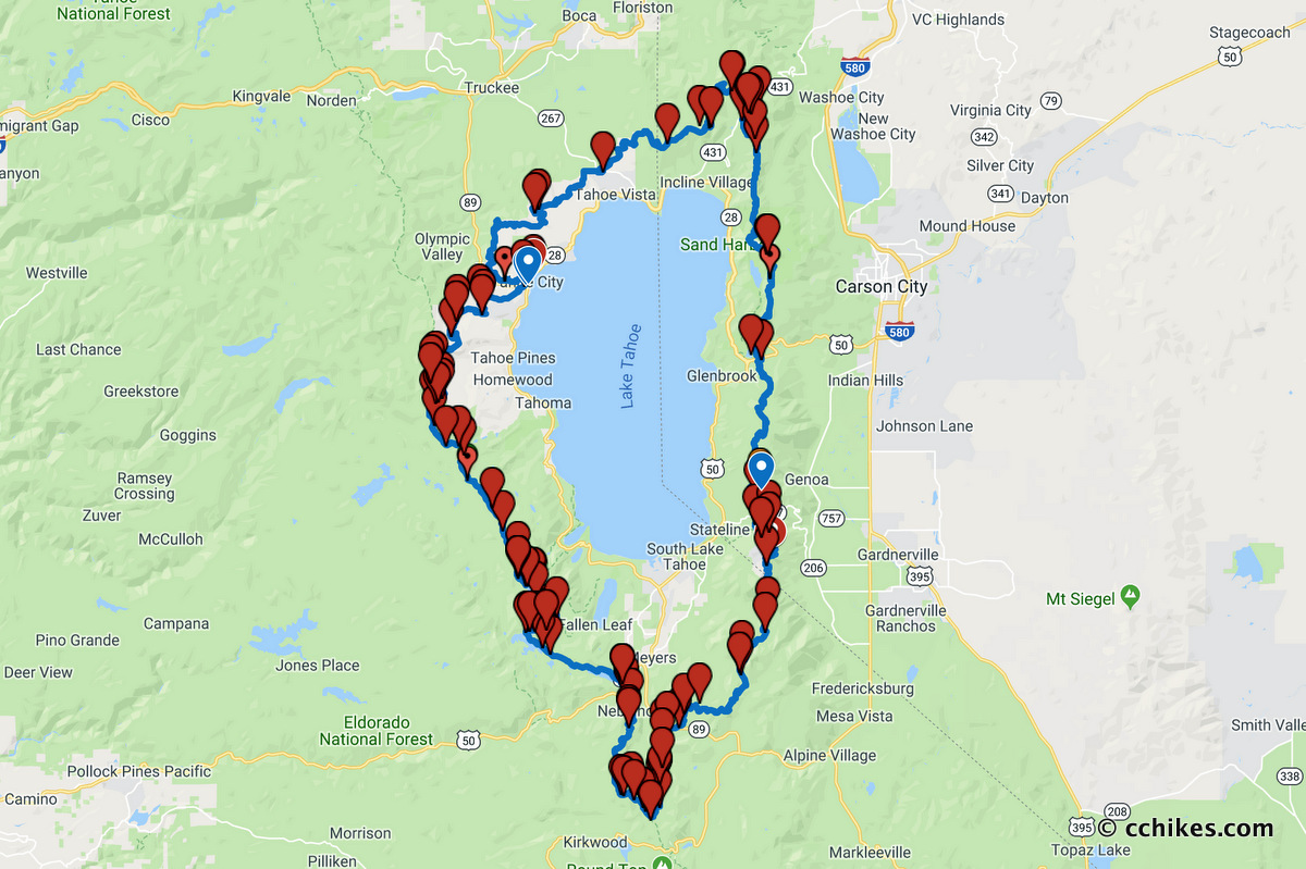
The TRT is a 173-mile loop (according to Guthooks) around the Lake Tahoe Basin in the Sierra Nevada and Carson ranges of California and Nevada. The elevation ranges from 6240 feet at the outlet of Lake Tahoe to 10,338 feet at Relay Peak in Nevada. The TRT shares a path with the Pacific Crest Trail for about 50 miles. Only one part of the loop requires a permit, and that’s the Desolation Wilderness. Well, there’s also a campfire/stove permit that’s required in the California sections, but it’s free and easy to obtain online. TRT thru-hikers are not dependent on the permit lottery. They simply have to pay for a permit no earlier than 2 weeks before they plan to use it to hike through or overnight in the Desolation Wilderness. It can be done over the phone or in person at one of the park offices. That’s the only limiting factor in planning a thru-hike of the TRT.
Not having to shuttle from one end to the other makes this a very attractive long-distance trail. Best of all, there are two cities opposite the lake from each other—South Lake Tahoe in the west and Tahoe City in the east. You start your loop in one city and resupply in the other. That means you only ever have to carry enough food for half of your hike at a time. Plus, you can grab a hot meal and recharge your devices halfway through. That’s a huge motivator on the trail, even if you’re out there specifically to get away from civilization.
Pre-hike impressions
The Tahoe Rim Trail Association has a wealth of information on their website, including downloadable maps, water source updates, and permit process information. Judging by everything I’ve researched, the TRT seems to have the beauty of the High Sierra without the high mountain passes and the long climbs that come with them. It features lakes (obviously), evergreen groves, open meadows, and granite cliffs. It’s a wealth of landscapes all wrapped into one convenient loop with an even more convenient break in the middle. From what I’ve read, this should be much easier hiking than the High Sierra and the High Uintas. But that doesn’t mean it will be easy for me.
Before my accident, I would have banged out this trail without thinking twice. Not so much anymore. I have no doubt that I will have my muscles and lungs in shape for this hike by late August. But I don’t know what effect that kind of exercise will have on my leg bones. It’s possible I may have to call this off. I’ll make that decision before I book my flight. At worst, I’ll be out the $15 in Desolation Wilderness permit fees. I’ll still do a hike somewhere, but it may have to be a shorter, flatter section somewhere.
I’ll update when I know more. Hopefully, it will be after I’ve completed the hike.


Scott Calley
Go for it. If you’re fit and prepared, your body will adapt. There will be pain but it will go away.
I’ve been there. Tib / Fib surgery w plates.